
The forecast wasn’t looking great—rain was on the radar—but after checking the details, it looked like the wet weather wouldn’t hit until the afternoon, and even then, it would be light. A few drops? No problem. So off we went.
We met at the corner of Stuart’s Road and Bottleneck Road in Katoomba, made our introductions, and set off on this adventurous circuit through the heart of the Blue Mountains.
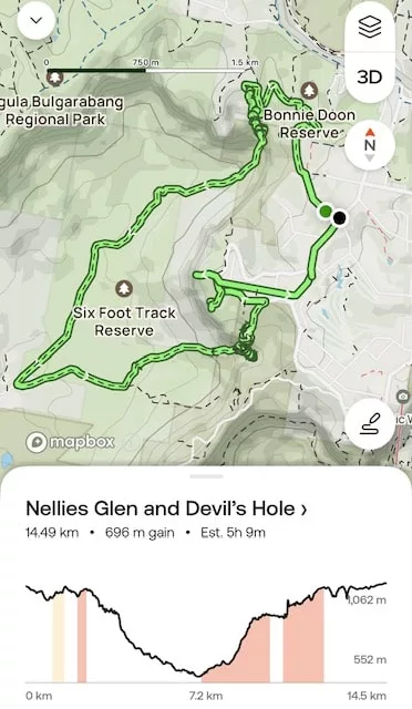
Devil’s Hole Circuit Hike Details
- When: 18 May 2025
- Where: Katoomba, Blue Mountains National Park
- Weather:Forcast of rain in the afternoon on a cold autumn day with a low of 36.3°F (2.4°C) and a high of 69.8°F (21°C)
- Departure: From the corner of Stuart’s and Bottleneck Roads, Katoomba
- Length: 14.49 km 9 miles
- Elevation Gain: Approx. 696 m 2282 ft
- Duration: 5 hours 9 minutes moving time
- Difficulty: Grade 4 – Moderate to hard
- Highlights: Therebulat Lookout, North’s Lookout, Bonny Doon Falls, Devil’s Hole, Devil’s Creek Falls, secret lookout, Boars Head, Cahill’s Lookout
- Track Type: Mix of defined walking tracks, fire trails, and short off-track scrambles
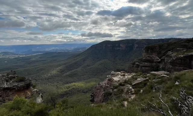
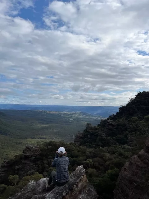
The Start – Cliff Walk Track to Therebulat Lookout
We followed Stuart’s Road down to the trailhead for the Cliff Walk Track, our first goal being Therebulat Lookout. The clouds were hanging around, but surprisingly, there were patches of blue sky over Megalong Valley—so much for that gloomy forecast!
North’s Lookout – More Epic Blue Mountains Views
After a short backtrack from Therebulat, we continued along the Cliff Walk to North’s Lookout, soaking in more sweeping views across the valley. This section of trail was mostly undulating but easy, following a clear and well-maintained path.
Joining the Six Foot Track – A Step Back in Time
Next, we turned onto the historic Six Foot Track, originally built in 1884 as a bridle trail to the Jenolan Caves. It gets its name from its width—six feet (1.8 meters)—wide enough for two horses to pass.
This 45 km (28 mile) track is now a popular multi-day hike, though some of us have done it in a day. Today, we were just sampling a scenic section as we descended toward Nellie’s Glen and Bonny Doon Falls.
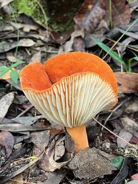
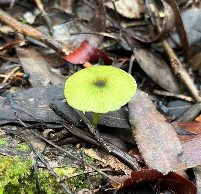
Thanks to 8 mm of rain the night before, the track was slick in places and required a bit of care on the descent. But the payoff? Fungi of every colour, shape, and size. We stopped often to admire and photograph these little forest treasures.
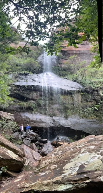
Morning Tea at Bonny Doon Falls
We settled on a big flat rock at the base of Bonny Doon Falls for a well-earned break. The misty air and tumbling water made it a dreamy spot for morning tea.
From here, we continued another 3.4 km (2.1 miles) along the Six Foot Track, enjoying changing terrain and more fungi sightings before reaching Water Board Road—the lowest and halfway point of our hike.
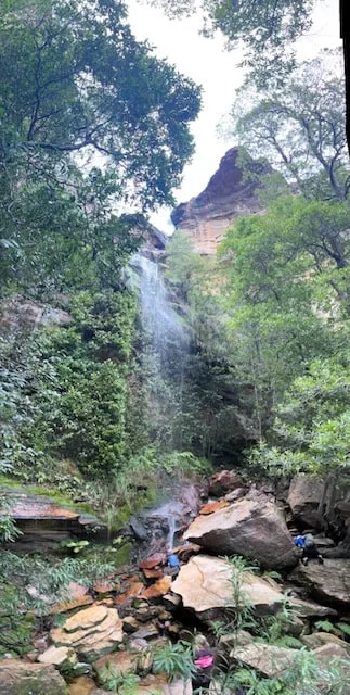
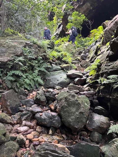
Climbing to Devil’s Creek Falls
We followed Water Board Road for 1 km (0.6 miles) before turning off onto the Devil’s Hole Track. The next 2.4 km (1.5 miles) was all uphill as we made our way to the falls.
This side trip involved a steep, slippery scramble down to the falls. With wet rock underfoot, we had to take it slow, but everyone made it safely. We stood among giant mossy boulders at the foot of the waterfall—pure Blue Mountains’ magic.
Lunch Among Giants – Then the Devil’s Hole Ascent
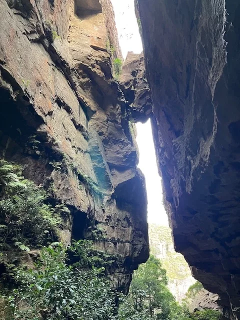
We had lunch at Devil’s Creek Falls before tackling the short but sharp ascent up Devil’s Hole. This is where the real fun began.
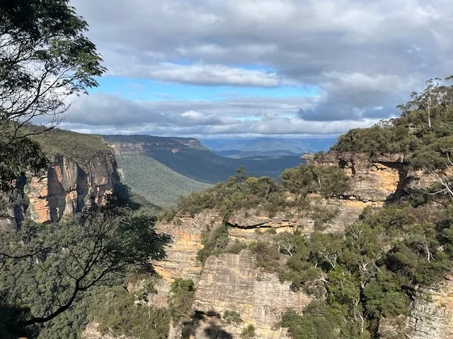
One of the most jaw-dropping parts of this hike is the narrow chasm known as Devil’s Hole, with sheer cliffs rising on either side and a giant boulder wedged between them, forming a natural stone arch overhead. It’s eerie, beautiful, and unforgettable.
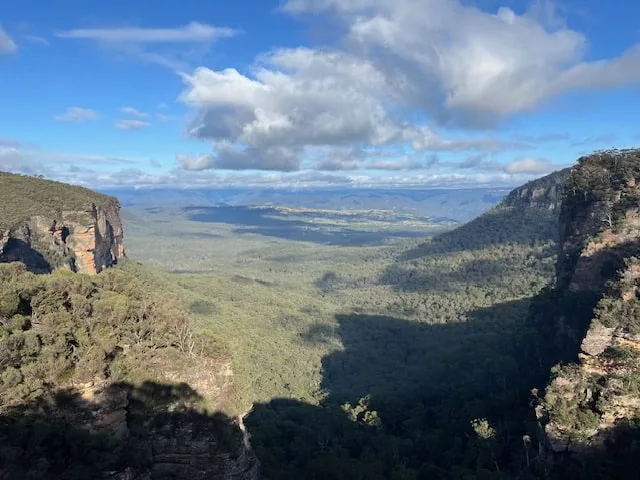
A Secret Lookout + Boars Head Rock
At the top, we took a short detour to a secret, unnamed lookout with epic views across the valley—back over much of the trail we’d just hiked.
From there, we continued the final 200 meters (660 feet) of the Devil’s Hole Track to reach Cliff Drive. We made a quick side trip to Boars Head Lookout, where the rock formation really does resemble a wild boar’s head.
Final Stop – Cahill’s Lookout
The last scenic stop of the day was Cahill’s Lookout, a classic Blue Mountains viewpoint. From there, we strolled through quiet backstreets to return to our waiting cars.
The Terrain
Rated Grade 4, this hike includes some steep scrambles plus slippery descents along with a bit of off-track adventure, especially down to the falls. The recent rain added an extra layer of challenge, but that just made it more exciting. If you’re up for a hike that’s a little wild and full of variety, this Blue Mountains trail is one to add to your list.
Flora and Fauna
Descending through Nelly’s Glen you will pass through a variety of Blue Mountains’ vegetation including:
- Towering eucalypts on the upper slopes
- Coachwood and sassafras in the shaded gullies
- Treeferns, mosses and lichens along the creek beds
- In the Autum and early winter there is an abundance of fungi is various shapes, sizes and colours.
- In the Spring and early summer wild flowers including waratahs and mountain devils
The animals you can expect to see or hear include:
- Lyrebirds in the undergrowth can be heard mimicking other birds
- swamp wallabies
- In the trees a variety of colourful birds including rosellas, king parrots
- There’s even the possibility of an ancouter with an echidna or blue-tongue lizard.
- In the summer months snakes such as brown, red bellied black, diamond pythos and tiger snakes are a possibility. I have a blog on dealing with snake bites here.
My Final Thoughts
The Devil’s Hole Circuit is an unforgettable hike in Katoomba that packs in a little bit of everything—clifftop lookouts, lush rainforest, waterfalls, fungi, and a natural stone arch you won’t believe until you see it. Extra care is needed if tackling this hike after rain as the scrambling sections become slippery but with care, it’s doable.
Have you hiked this route? If so, I’d love to hear of your experience.