
Our adventure on this day took us through a stunning section of the new Snowies Alpine Walk, a 56-kilometer, four-day self-guided trail winding through the Thredbo-Perisher region. While the full walk promises an epic experience, we opted for a single-day trek, covering the stretch from Perisher to Bullocks Flat.
With a bit of planning ahead, we arranged for cars to be waiting for us at Bullocks Flat. It’s moments like these that remind me—good preparation really does make for a smoother hike.
Snowies Alpine Walk from Perisher to Bullocks Flat
- When: 19 December 2024
- Where: Kosciusko National Park
- Weather: Clear and still summer’s day with an overnight low of 32F (0C) and a high of 77F 25C).
- Departure: From Perisher Valley Ski Resort
- Length: 7.95 miles, 12.8 km
- Elevation gain: 456 ft, 139 m
- Duration: 3 hours 35 minutes moving time

Starting the Journey
Our trailhead was perched at the Perisher ski resort. Heading downhill from Perisher, we avoided the challenge of an 800-meter ascent, which would have made for a far tougher day. The trail offered a blend of terrains—metal boardwalks, steps, paved paths, and stretches of earthy dirt.
Early on, we crossed Rock Creek via two metal bridges, and soon found ourselves wandering through a woodland of snow gums with their gnarled, white trunks, and towering alpine ash trees.

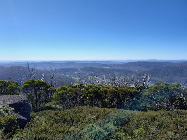
Morning Tea with a View
After about 3.5 kilometers, we reached a lookout offering breathtaking views over the Thredbo Valley and the Monaro Plains. This was our perfect spot for a quick morning tea break, surrounded by expansive vistas that seemed to stretch forever.
Cooling Off and Lunchtime Bliss
As we pressed on, the trail led us to an alpine creek, where I couldn’t resist wetting my hat and hiking towel which I placed around my neck. There’s something about alpine streams—cold, fresh, and rejuvenating.
Lunch was deep within the forest, where the trail’s metal boardwalk provided a convenient perch. Dangling our legs over the edge, we enjoyed the cool, shaded spot beside another creek. It was one of those moments where the forest’s quiet and the sound of trickling water made everything feel at peace.

Descending to the Thredbo River
The descent steepened, but the sturdy metal steps made it manageable. As we moved further down, the scenery transitioned from eucalypt forests to a marshy plain before we reached the Thredbo River. This serene riverside setting could have been our perfect lunch spot if we hadn’t already eaten. We lingered for a moment, hoping to spot some trout in the clear waters, but they proved elusive.
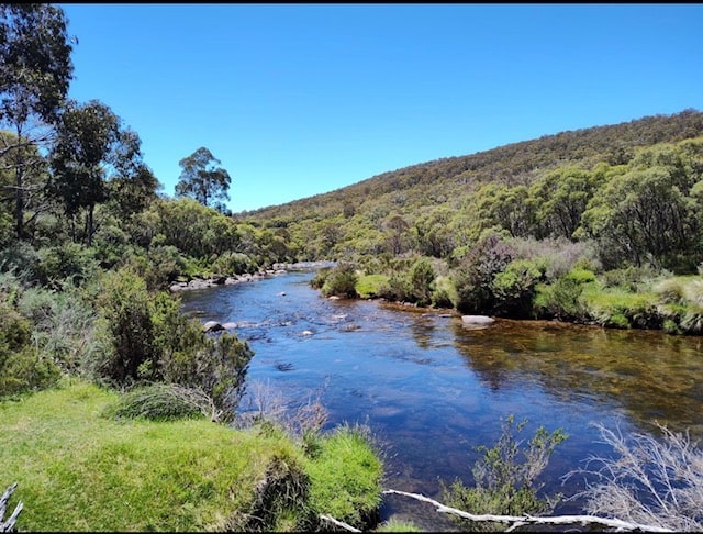
The Final Stretch
The last leg of the hike followed the Thredbo River, a beautiful way to end the journey. The path was gentle and scenic, leading us straight to our waiting cars at Bullocks Flat.
My Final Thoughts
This section of the Snowies Alpine Walk is a rewarding, straightforward hike, especially when taken downhill. Doing it in reverse would have made for a very different—and far more strenuous—experience! After the challenge of summiting Mount Kosciuszko the previous day, this trek offered a contrast. It was an easygoing hike full of diverse landscapes, cool creek stops, and stunning views—a perfect way to soak in the beauty of the Snowy Mountains. Would I do it again? Absolutely. Next time, I might even tackle it uphill… maybe. Happy Hiking!
If you have any questions or experience on the new Snowies Alpine Walk, I’d love to hear from you.