
Kamarah Creek Canyon is a true hidden gem in the Blue Mountains, accessible only via off-track hiking—or as we say in Australia, good old-fashioned bush-bashing. This hike is not for the faint-hearted, but if you’re up for an adventure, it’s absolutely worth it.
We had already warmed up with a short walk to Dargans Arch (which you can read about [here] – insert link) and were ready for the main event. With temperatures forecasted to hit the mid-30s°C (~95°F), I made sure to pack 4 litres (1 gallon) of water—a necessity on an unseasonal hot autumn day.
Kamerah Creek Canyon Hike Details
- When: 15 March 2025
- Where: Bell, Blue Mountains National Park,
- Weather: A hot autumn day. Low of 68°F (20°C) and a high of 89.6°F (32°C)
- Departure: Trailhead off Bells Line of Road, Bell
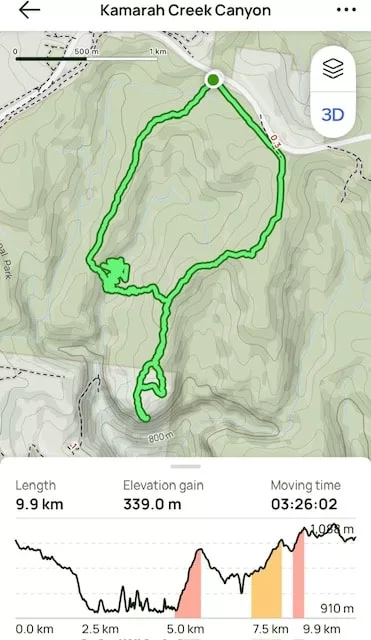
- Length: 6.15 miles, 9.9 km
- Elevation gain: 1112.2 ft, 339 m
- Duration: 4 hours 25 minutes moving time
Starting the Hike Kamarah Creek Canyon Hike
The adventure began off Bells Line of Road, though calling it a trail would be generous. A barely visible footpad marked the starting point, but with compasses in hand, we followed our leader, who had mapped out navigation points to test our skills.
The plan was to stay on the ridge for about 1.8 km (1.1 miles) before making a sharp descent into Kamarah Creek Gully. Using natural landmarks—the ridge crest, tree lines, and terrain features—we kept our bearings.
Descending into Kamarah Creek Gully
Having done this route before, our leader knew the exact point where we needed to descend. The goal was to reach the saddle, a low point between two higher ridges, before veering eastward into the gully.
Without a trail to follow, the descent became steep, requiring careful foot placement—one misstep could have meant serious injury. The loose terrain made things tricky, but eventually, we reached the cool, shaded depths of the canyon.
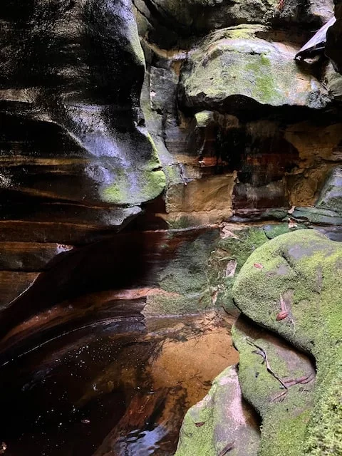
Morning Tea in Kamarah Creek Canyon
Stepping into the canyon, we immediately felt the temperature drop—a welcome relief from the heat.
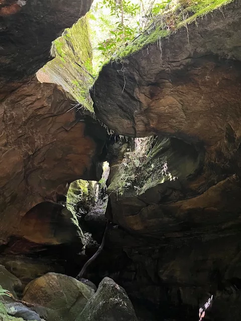
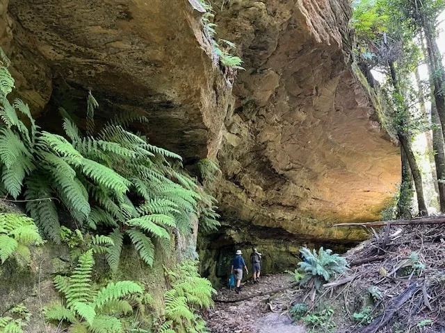
The narrow sandstone canyon, no more than 10 metres (33 feet) wide at its broadest point, was lined with an arc shaped rock overhang on the western side, creating a shady, tranquil refuge.
The sandy creek bed was lush with tree ferns, making it feel like a hidden tropical oasis. Cold water trickled from the rock overhang, and I couldn’t resist standing underneath to cool off.
Exploring Kamarah Creek Canyon
After eating, we headed deeper into the canyon. As the walls closed in, the light dimmed, filtering through rock formations that looked like interlocking jigsaw pieces. This place was a photographer’s heaven.
At the canyon’s end, we reached a shallow pool, enclosed except for a narrow 30 cm (12-inch) opening that allowed a sliver of light to enter. With no way forward, we turned back—ready for the challenging climb out.
Climbing Out of Kamarah Creek Canyon
The western ascent was tough—107 metres (351 feet) of elevation gain over just 120 metres (394 feet) on the map. The steep, off-track climb required scrambling in sections, but once we reached the top, the hard work paid off.
We followed the ridge line, aiming for our lunch spot, which promised spectacular views over the Grose Valley.
A Minor Detour
After 200 metres (656 feet) of bush-bashing, our leader realized we were on the wrong ridge! A quick adjustment had us back on track, and soon we were rewarded with one of the best lunch views imaginable—sandstone cliffs of the Grose Valley towering over a sea of gum trees.
The Final Push Back
The final 3.3 km (2 miles) back to the car felt brutal in the heat, despite being the easiest section of the hike. With a 100-metre (328-foot) elevation gain, it was a steady trek—but it was the hottest part of the day and I would have loved to have been back in the cool of the canyon.
Track Conditions
- Navigation: This is an off-track hike requiring compass navigation. No marked trails exist.
- Terrain: Steep, loose slopes with rock scrambling in places. and pushing through scrub and bush. The canyon floor is sandy and shaded.
- Difficulty: Grade 4 – suitable for experienced hikers with strong navigation skills.
- Hazards: Unstable footing, slippery rock surfaces, and potential heat exhaustion in summer or on hot days.
Flora & Fauna
Flora
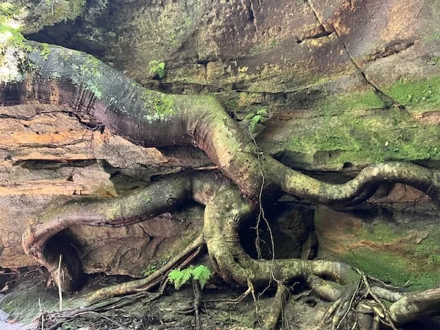
The cool, sheltered environment of Kamarah Creek Canyon supports an incredible range of plant life. The canyon floor is dominated by tree ferns and moss-covered boulders and rock faces, creating a lush, green landscape.
Along the ridges, we passed through open eucalyptus forest, where towering gum trees cast dappled shade. Some sections were bushy with sharp and spikey leaves – long pants and long sleeves are recommended to avoid scratches. Bottle Brush, Banksia and Waratahs trees were in abundance, though not in bloom.
Wildlife Common to This Area
- Superb Lyrebirds scratching in the leaf litter – these birds are amazing at mimicing all sorts of sounds
- The occasional wallaby darting through the undergrowth
- Skinks sunbathing on warm rock surfaces
My Hiking Essentials for Kamarah Creek Canyon
- Water: At least 4 litres (1 gallon) per person, plus electrolytes if you are prone to sweating. Here are the electrolytes I recommend.
- Navigation: Compass & topo map (GPS can be unreliable)
- Clothing: Long pants & sleeves (for bush-bashing)
- Footwear: Sturdy hiking boots with good grip
- First aid kit: Essential for off-track adventures
- Sun protection: Hat, sunscreen, sunglasses
My Final Thoughts
This Grade 4 hike is one of the best I’ve done in a long time. The stunning canyon scenery made the challenging terrain and heat totally worthwhile.
The best part of off-track hiking? Exploring places that few people ever get to see. I’d do this hike again in a heartbeat—and if you love a good adventure, I highly recommend adding Kamarah Creek Canyon to your list! Happy hiking!
Have you hiked Kamarah Creek Canyon?
Drop a comment below—I’d love to hear about your experience!