
Exploring new trails is always exciting, and this hike took me through a part of Sydney I hadn’t explored before. Normanhurst, a suburb on the Upper North Shore, is about 22 km northwest of the CBD. The route promised a mix of bushland, rock formations, and creek crossings—all the ingredients for a great day hike.
Normanhurst To Dural Hike Via Natural Arch Overview
- When: 27 March 2025
- Where: Lane Cove National Park, Berowra Valley Regional Park and Dural Nature Reserve.
- Weather: A warm but very humid autumn day with rain forcast Low of 66.2°F (19°C) and a high of 73.4°F (26°C)
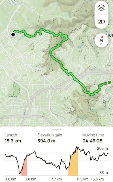
- Departure: Normanhurst train station return to James Hentley Dr, Dural
- Length: 10.4 miles, 16.8 km
- Elevation gain: 1292 ft, 394 m
- Duration: 5 hours 05 minutes moving time
Setting Off from Normanhurst
Our group of ten met at Normanhurst Train Station, setting off not long after 8:30 am. The hike began with about 1.5 km of road walking (which I forgot to record—classic mistake) before reaching our first trailhead off Elizabeth Street.
From here, the trail ran parallel to Coups Creek, starting with a gentle descent before transitioning into undulating terrain. The forecast had suggested a reasonable chance of a small amount of rain, and the track was slick with wet leaves, making footing a bit tricky.
At around the 1.2 km mark, we crossed Coops Creek and Comenarra Parkway before facing our first real challenge—a steep, slippery descent. But that wasn’t the only hazard of the day. The damp conditions brought out plenty of leeches, and while I managed to avoid most of them, one of my hiking mates was a leech magnet, attracting far more than their fair share! You can read more about these sneaky creatures here.
Morning Tea Stop at Thornleigh Oval
As every hiker knows, what goes down must come up! We ascended as we followed the Great North Walk into Lane Cove National Park, eventually reaching Thornleigh Oval. Here, we stopped for morning tea, did a thorough leech check, refilled water bottles, and took advantage of the toilets.
Through Berowra Valley Regional Park
After the break, we had another 2 km of road walking—just in time for the forecasted rain to arrive. I pulled on my rain poncho, while others opted for jackets or braved the rain without cover (there’s always a debate about the best wet weather gear—I’ll save that discussion for another blog!).
We rejoined the bush trail at Morgan Street, descending into the park alongside Zig Zag Creek. The path continued downwards, crossing Berowra Creek a couple of times—along with even more leeches. We followed the creek for a while before climbing towards Eloura Lookout, where we had an exciting wildlife sighting—a wallaby!
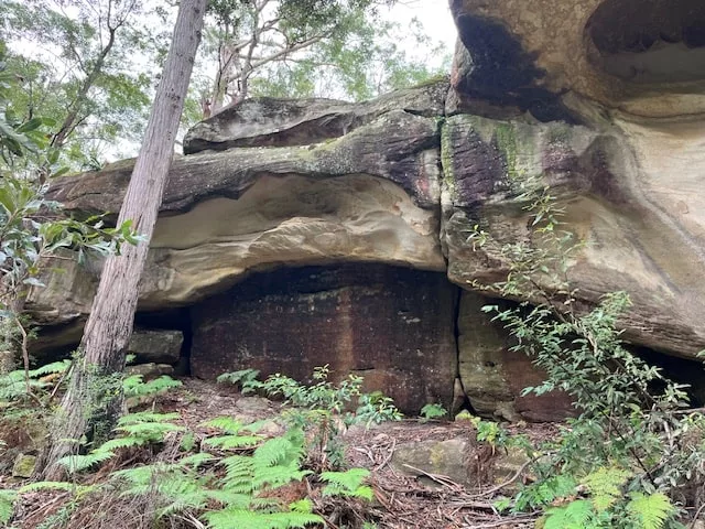
Natural Arch – A Sydney Bushwalking Treasure
With another climb, we turned onto Refuge Rock Track, making our way up to Natural Arch, a striking natural rock formation. Locals call it “London Bridge” because of its shape.
Arriving at a large rock platform, we found it was actually split into two, separated by a narrow slot—so narrow that I had to take my backpack off to squeeze through! Emerging from the passage, I was greeted by the arch itself, which was incredible to walk under and around.
We took a break here for lunch on top of the rock platform, soaking in the scenery before moving on to Refuge Rock. This vast rock expanse was once used for mortar practice during WWII and now serves as a safe refuge for firefighters during controlled burns.
Crossing the New Swing Bridge
This next stretch of the hike involved a few track changes. We first followed Trevors Lane Trail, skirting the park’s edge, then joined Carmen Trail (named after Carmen Crescent) before reaching Kentia Trail. This led us to one of the newest features of the hike—a swing bridge built in 2023, crossing Peyes Creek.
From there, we navigated around Fallon Reserve and Dural Nature Reserve, eventually reaching James Henty Drive Oval. A short five-minute walk brought us to our bus stop to take us to Cherrybrook metro stop for our ride home.
Track Conditions
- Trail Type: A mix of bush tracks, fire trails, rock platforms, and road walking
- Difficulty: Moderate – some steep sections, creek crossings, and slippery surfaces
- Terrain: Rocky and uneven in places, especially around Berowra Creek and Natural Arch
- Weather: A rain shower and humidity made the track muddy, leech-friendly and slippery.
Flora & Fauna
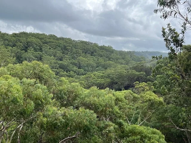
- Flora: Lush eucalypt forests, ferns, and the last patches of wildflowers added bursts of color along the trail. The area around Natural Arch featured weathered sandstone formations, making for dramatic landscapes.
- Fauna: We spotted a swamp wallaby near Eloura Lookout, and birdwatchers in the group identified various native species, including kookaburras and black cockatoos though other species such as lyrebirds, various owls, rainbow lorakeets, king parrots are known to inhabit this area along with Eastern water dragons, goannas, diamond pythons, eastern brown snakes and green tree frogs. Of course, the most ‘interactive’ wildlife of the day was the leeches!
My Final Thoughts
Despite the rain, humidity, and persistent leeches, this was an enjoyable hike in a part of Sydney I hadn’t explored before. The diverse terrain, from creek crossings to rock formations, made it an interesting and rewarding route.
And yes, I did end up with a sneaky leech bite that I only noticed once I got home—but that’s all part of the adventure! Would I do it again? Absolutely. Maybe with extra leech repellent next time! Happy hiking!
Have you hiked in this part of the world? Please leave your comments or questions below.