
This hike was a bit of a mishap — and my first ever solo hike.
Silly me, I was busy writing a blog post on hikes in Italy (please read it [here]) when I completely missed my train stop for a club hike. Oops!
Just as I realised, I got a call from the hike leader. I apologised profusely and told her I’d figure something out on my own. I hopped off at the next stop and caught the next train back to Springwood, hoping to catch up with the group.
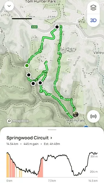
I had a rough idea of their route, but there was a “twist” I wasn’t sure about. I turned to AllTrails, plotted what I thought might be the planned route, and downloaded the map.
Springwood Circuit Hike Details
- When: 24 April 2025
- Where: Sassafras Gully Reserve and Blue Mountains National Park, Springwood NSW
- Weather: Slight chance of rain forcast on a warm autumn day with a low of 59°F (15°C) and a high of 75.2°F (24C)
- Departure: From Springwood train station, finishing at Springwood train station.
- Length: 9:32 miles, 15 km (approx)
- Elevation gain: 1476 ft, 450 m (approx)
- Duration: 4 hours 49 minutes moving time
Travelling Solo on the Magdala Gully Track
Initially, I was a little nervous — I’d never hiked solo before. But I made sure my daughter knew where I was and we use a tracking app so she could follow my location. Plus, the hike was all on-track, and my group was somewhere nearby.
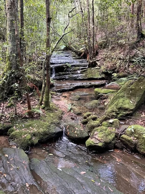
The first 4.6 km ( 2.86 miles) of the hike was mostly downhill, following the Magdala Creek. Earlier rain had left the track wet and slippery. Since I was on my own, I took extra care, especially at the many creek crossings where the trail zigzagged to avoid impassable rocky outcrops.
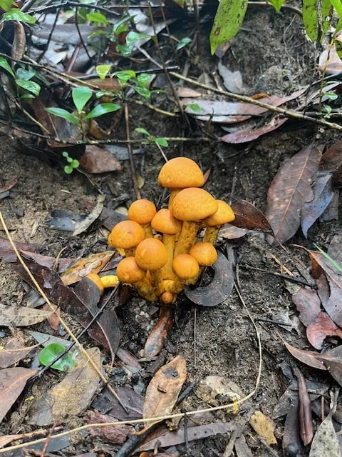
The rhythm of walking helped ease my nerves, and soon I found myself enjoying the quiet — and the freedom to stop and admire fungi or a cascade whenever I wanted.
Morning Tea at Magdala Falls
I’d decided that the lookout at Magdala Falls would be a good morning tea stop. By then, I was hungry — and being solo, I ate and promptly moved on!
After the falls, I turned onto an old, barely-used track marked on AllTrails. I figured this could be the “twist” my group leader had mentioned. The ascent was immediate and steep — around 150 m ( 492 feet) elevation over a kilometre or 0.62 miles. I had to stop often and check my map to stay on course.
Eventually, I reached a ridge line and found myself on a fire trail: the Yondell Avenue Extension Trail. I’m not a fan of fire trails, so when I spotted a clear track veering off, I decided to take it. It wasn’t marked on the app, but it looked well-worn and was heading in the right direction. If it led to nowhere, I would simply turn back.
Sure enough, it led me to Yondell Road, and from there it was a short road walk to the Wiggins Track trailhead.
The Potential Track Closure
At the trailhead, a sign warned that the Victory Track to Faulconbridge was closed due to landslides. That was bad news — I needed that track to complete my loop. Feeling a bit deflated, I began walking back toward the station.
But when I checked the National Park’s website, I saw that the section I needed was open. Lucky me!
An Unexpected Meeting
Not long after setting off on Wiggins Track, guess who I ran into? Yep — my group! We had a quick chat, swapped stories, and said our goodbyes.
The Steep and Slippery Descent on Wiggins Track
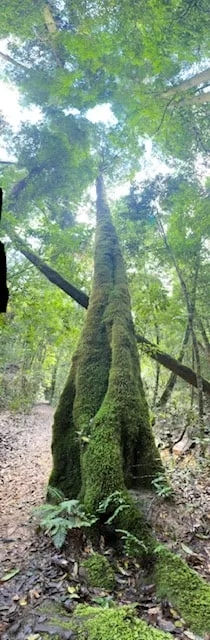
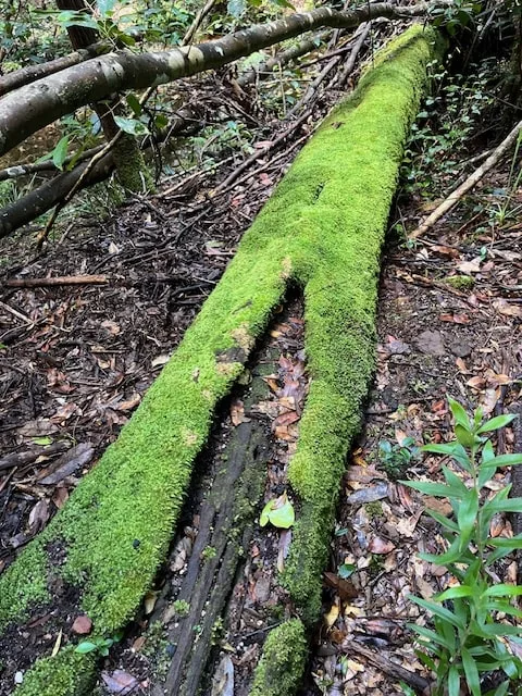
Much like my earlier climb, this section brought a steep descent — made even trickier by the wet, mossy rocks. I’d now entered the Blue Mountains National Park and reached Sassafras Creek, a cool, dense green world where moss covered everything from boulders to tree trunks.
The Final Leg: Victory Track and Sassafras Gully Walking Track
After crossing the creek, I turned onto the Victory Track. The trail followed the creek closely, requiring more careful crossings over slick stones.
I eventually reached the Sassafras Gully Track junction — clearly marked, since the rest of the Victory Track was still closed due to landslides. From here, it was a final climb out of the gully to the trailhead at Sassafras Gully Road.
Then it was a short walk along the road back to Springwood Station — tired, happy, and proud of how the day turned out.
Terrain and Track Conditions
This hike offers a variety of terrain, from gentle fire trails to rugged rocky tracks and steep ascents/descents. The route includes:
- Slippery rock crossings and wet sections after rain
- A steep ascent of ~150 m on the Old Yondell Track
- Fire trails and unmarked tracks that require good navigation
- A sharp descent into Sassafras Gully with moss-covered rocks
- Numerous creek crossings, often with slick stepping stones
Sturdy hiking shoes and trekking poles would be very helpful, especially in wet conditions.
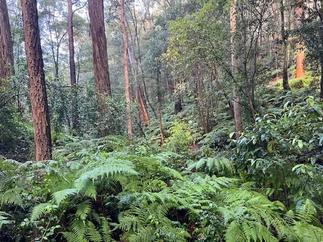
Flora and Fauna
Springwood is rich in Blue Mountains biodiversity. Along the track, I spotted:
- Mosses and lichens carpeting boulders and trees
- Various fungi, especially after the recent rains
- Ferns and native shrubs lining the gullies
- Towering eucalypts, she-oaks and banksia
- I managed to spot an elusive lyrebird that scuttled off into the bush before I could snap its photo. The area is also home to swamp wallabies, and countless bird species. Keep your ears open for bird calls and your eyes peeled near the creeks.
My Final Thoughts
What started as a disastrous day ended up being a powerful learning experience and my first solo hike.
It couldn’t have come at a better time — I’ve decided it’s time to start leading walks, and this gave me the confidence boost I needed. My instincts helped me complete the walk safely, and I’m proud of how I handled the unexpected. Happy hiking!
Have you ever hiked solo? Please leave your experience here.