
Looking for a lesser-known hike in the Lower Blue Mountains with great views and varied terrain? The walk from Warimoo to Blaxland via Green Point offers bush tracks, fire trails, a dramatic lookout, and lush forest landscapes — perfect for adventurous walkers who enjoy a mix of scenery.
On the western side of the Great Western Highway in the Lower Blue Mountains, it is in the same area as last week’s walk (you can read about that one here).
Warimoo To Blaxland Via Green Point Hike Details
- When: 4 June 2025
- Where: Lower Blue Mountains, NSW. Starting at Valley Heights train station and finishing at Blaxland Station
- Weather: cold and overcast winter’s day with a low of 48.2°F (9°C) and a high of 68.8°F (16°C). Rain in the morning clearing in the afternoon and blustery conditions.
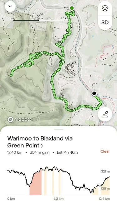
- Length: 12.4 km (8 miles)
- Elevation Gain: ~354 m (1,161 ft)
- Duration: Around 4 hours 46 minutes moving time
- Difficulty: Grade 3 – Moderate
- Track Type: Fire trails, footpads, and well-defined walking tracks
- Terrain: Some steep sections, creek crossings, narrow bush tracks and slippery, rocky tracks
- Highlights: Sweeping views over the Glenbrook creek valley
The Start
We were a group of 20 walkers, and with rain already falling, we geared up in our wet weather layers before heading out. After crossing the pedestrian bridge over the highway, we walked a short distance along the road before turning off into the bush on an unnamed track and beginning a gentle descent.
At 2.3 km (1.4 mi) from Warimoo Station, we turned left onto Flora Bella Pass. The trail narrowed and, at the 2.6 km (1.6 mi) mark, we reached our first creek crossing — it was straightforward and manageable.
Shortly after, the ascent began, and at 3 km (1.9 mi), we turned right onto The Greens Road Powerlines Access — a wide fire trail that took us to our morning tea spot. Our goal was Green Point, a lookout with sweeping views over the Glenbrook Creek valley.
At 4 km (2.5 mi), we turned left onto an unnamed track and followed it for 200 meters (0.1 mi), before turning left again onto Greens Road, an undulating fire trail. With all these turns, it was important to stay aware of the route — this area is full of unmarked tracks.
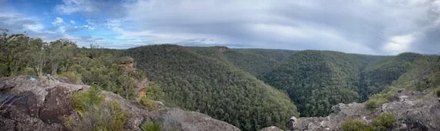
We reached the lookout at the 5.2 km (3.2 mi) mark, walking out onto a large rock platform. The view over the lush valley below was well worth the short detour — but strong winds and cold temps chased us back to the main track where we stopped for morning tea.
Onwards to Blaxland
After sustenance, we retraced our steps for 600 meters (0.37 mi). At 5.8 km (3.6 mi), we turned right onto another unnamed bush track and followed it for 1 km (0.6 mi), rejoining the Powerlines Access Trail at the 6.8 km (4.2 mi) mark. From here, it was a gentle descent back to Flora Bella Pass.
At 7.6 km (4.7 mi), we turned right and continued descending along Flora Bella. By 9.8 km (6.1 mi), we found a rocky outcrop that made the perfect lunch spot — elevated and with just enough flat space to stretch out.
After lunch, we continued the descent along Flora Bella, crossing a tributary of Glenbrook Creek. The final climb of the day began here. About 1 km (0.6 mi) later, the track becomes known as Pippa’s Pass. One last creek crossing and we arrived at the trailhead near Blaxland Public Library on Hope Street.
After a short road walk and a crossing over the pedestrian bridge, we arrived at Blaxland Station.
Flora and Fauna
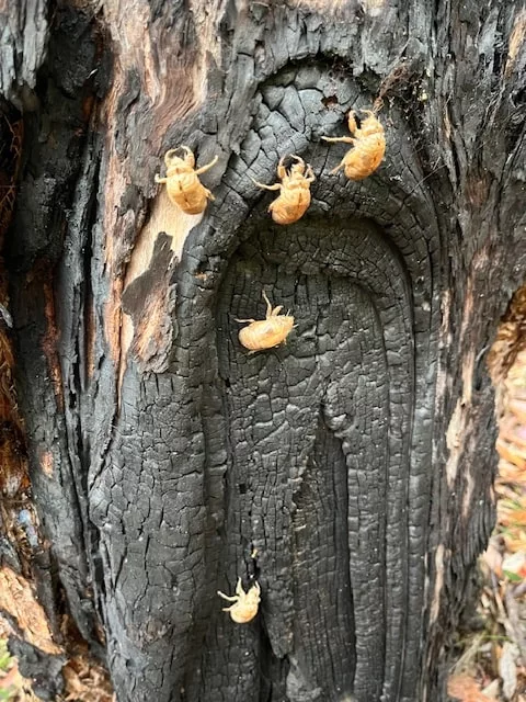
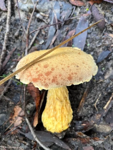
This walk offers a rich sample of Lower Blue Mountains biodiversity. Towering scribbly gums, Sydney peppermint, and red bloodwoods form the canopy, with wattle and banksia along the understory. After the rain, the bush was vibrant and fresh. Many varieties of fungi were still spotted along the route.
Birdlife was abundant. We heard the calls of eastern whipbirds and lyrebirds echoing through the valleys. Crimson rosellas and king parrots flashed through the trees.
We didn’t see any reptiles, likely due to the damp conditions, but this area is known for occasional sightings of diamond pythons and bluetongue lizards in drier weather.
Track Conditions
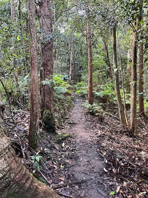
The track was a mix of fire trails and bush tracks. The fire trails (like the Powerlines Access and Greens Road) were wide and clear, with gentle gradients. The bush sections, especially Flora Bella Pass and Pippa’s Pass, were narrower and more rugged.
Rain made parts of the trail wet and slippery, particularly on rocky descents and at creek crossings. Proper footwear with good grip was essential. While the creeks were crossable without too much trouble, care was still needed on the slick rocks. this is where hiking poles con come in handy.
There were many junctions with unmarked trails, so having a GPS or detailed route notes was crucial. This isn’t a hike where you can just wing it — local knowledge or prior planning helps a lot.
My Final Thoughts
This was a varied and rewarding hike with everything from forested bush tracks to scenic fire trails. The lookout at Green Point was a real highlight, offering expansive views of the Glenbrook Creek valley — a fantastic spot even in blustery weather.
This less popular side of the Great Western Highway feels more rugged and untouched than the eastern trails. There’s a real sense of discovery, especially with the network of unnamed tracks. It’s definitely worth exploring if you enjoy a mix of terrain and aren’t afraid of a bit of route-finding.