
This hike had me excited as due to a train mishap I had missed visiting Dargan Arch a few months back, so I jumped at the second chance to get there. The hike located in the Blue Mountains National Park, famous for The Three Sisters, started near Bell train station, just under 80 miles or 130 km west of Sydney.
Gooch’s Crater Hike Guide – Including Dargan Arch
- When: 13 July 2024
- Where: Blue Mountains National Park, out to Dargan Arch then on to Goochs Crater Track with a bonus unplanned side trip to Billabong Canyon then on to Goochs Crater and back directly to out start point.
- Weather: Cloudy and cool Sydney winters day with cold winds from the south west at 12 m/hr or 20 km/hr. Low of temperature of 33.8 F (1 C) and a high of 48.3 F (9 C).
- Departure: A short drive from Bell train station on a dirt road starting the walk at around 9:30 am and arrived back at the station at 4:08 pm
- Length: 9.6 miles, 15.44 km
- Elevation gain: 1,850 ft, 564 m
- Duration: 6:35 hours, plus breaks

The Start
Our group of 20 met at Bell train station as around 9:00 am. The walk was to start a short distance from the station so we jumped in our cars and drove along a dirt road to the start of the walk. Our first stop was Dargan Arch.
Dargan Arch
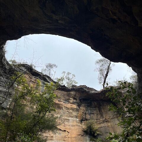
Our walk started along a firetrail which quickly turned into a dense bush track. After 0.62 miles or 1 km the arch, which is named after its closest town of Dargan, came into view. The arch is roughly 46 ft (14m) long and 16 ft (5m) wide. The arch is the remnant of the roof of a sandstone cave which collapsed.
We made our way down, along a ferny and somewhat slippery track, with a little creek crossing to the cave. Here we could look up at the arch with the sky behind it and take in the proportions of the cave.

Goochs Crater
Our next destination was Goochs Crater. This 4 mile (6.5km) hike could be best described as undulating with numerous ups and downs. Before we took off for good we scrambled up a pagoda to take in the views.
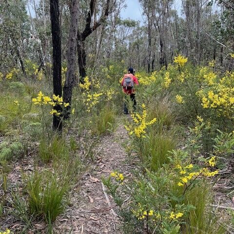
The path initially took us on a relatively flat section with eucalypts awash with bright yellow wattle bushes dancing around their bases. We stopped on a rocky outcrop for a quick morning tea.
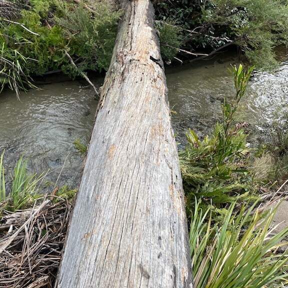
Our next next challenge was crossing the Wollagambe River, where we were expecting, but hoping not, to get wet feet. Luckily, nature’s bridge, a well placed fallen tree saved our feet. We all made it accross without falling in. Testament to our balance and nerve.
From here an ascent to the start of our easy walk along the ridge. This is where having the right gear comes in handy as it was exposed and blowy. The views from the ridge showing the vast expanse of the rugged bush country.
We now faced a short and sharp descent through a narrow gap in the cliff with towering pagodas surrounding us. At the base the path cuts through lush green ferns. It never ceases to amaze me how the vegetation can change in such a short distance.
We continue along the path until we come to a long, but shallow, cave or rocky overhang, perfect for a sheltered camp spot. We then encounter our next challenge: making our way up a short but steep and slippery rockface. Our trusty leader planned ahead and with the help of a long rope tied around a sturdy tree, we all made it up. This is where the importance of research and planning your hike comes into play. From here we made it to the top of the eastern side of Goochs Crater, our lunch spot.


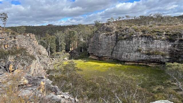
Goochs Crater, on the Newnes Plateau is a natural amphitheatre. It is a swamp which can become a lake after heavy rain. It is not volcanic in origin and is ringed by deeply under-cut pagoda rock formations. Its walls are up to 98 ft (30m) high and is approximately 345ft (205m) by 213ft (65m) wide at the northern end and narrows to 115ft (35m) at its southern end.
The crater is named in memory of Nicholas Andrew Gooch (28.3.1947 – 18.7.2003), who originally discovered this feature in 1978. It has since become a popular hiking destination.
Billabong Canyon
After lunch some of us made a suprise side trip to a close-by canyon. The short descent entailed crossing a little creek and slipping past a tight gap in two rocks, it was backpacks off for this, where we encountered the canyon with it small but crystal clear rock pool with a 6ft waterfall at one end. If it was summer, I would have jumped in.

Homeward Bound
The route home took us down a steepish path into the crater, here we walked along its eastern side. A slight deviation of our return ensured we bypassed the steep rock and need of a rope, ensuring a quicker return back to The Wollangambe river where our log bridge waited. Before we knew it we were on the fire trail and at our waiting cars, with our hike ending slightly before 4:00pm

My Highlights
Getting to Dargan Arch ofter my initial disappointment of missing it a few months ago. The abundance of bright yellow wattle adding a splash of colour to a cold and somewhat gloomy day. Lunch looking down into the crater below and the unexpected trip to Billabong Canyon wich I’m adding to my summer to do list. I think a good day was had by all. If you are interested in my previous hike, you can read about it here.
Happy Hiking!
If your curious or would like to leave a comment, you can do so below.
First of all, as I quickly scanned the topic, I thought it was connected in some way to the Blue Ridge mountains in the USA, how wrong I was. I do know of them, but not a single thing about the Blue Mountains in Australia in this article.
I really find this sort of story very interesting, so much detail for anyone to use if they are thinking of going there. If not just reading this article and experience just about takes you there, the photos give a great impression of the experience.
So now I feel I can say I do know about the Blue Mountains, near Sydney Austrailia, thank you for a great article
Bobby
Thank you. You are welcome. Stay tuned for my next adventure.
What an incredible adventure, Lyn! Your detailed descriptions made me feel like I was right there with you, navigating the bush tracks and marveling at the natural beauty of Dargan Arch and Goochs Crater. The surprise side trip to Billabong Canyon sounds like a hidden gem, especially with its crystal-clear rock pool. I’m curious, how do you prepare for these hikes in terms of gear and safety measures, especially when tackling challenging sections like the steep rock face you mentioned? Your stories are truly inspiring for fellow hiking enthusiasts!
Hi Hanna, thanks. When I pack I always plan for the worst, an overnight stay! I’ve never had to use my extra water, food, bivvy etc. This was a led walk and I knew of the steep section and the leader had a rope. It’s about taking your time and being careful of where you place your feet.
Hey Lyn,
What an incredible hike to the Dargan Arch and Gooch’s Crater! The photos you’ve shared are absolutely stunning – they really capture the dramatic, otherworldly beauty of these geological wonders. I’m so envious that you got to explore these unique natural landmarks up close.
This trip has been on my hiking bucket list for years, so I’d love to hear more about your experience. What were some of the highlights? How did the difficulty level compare to what you were expecting? Any tips for those of us hoping to follow in your footsteps next summer? This hike is definitely going on my list for next year. Thanks for sharing this amazing adventure!
Marios
Hi Marios. The only difficult bit was the section where we used a rope to climb up the rock face. It was wet so there was the slip factor. I’m very short so used the rope but being taller you could probably do it without a rope. If you are doing the hike in the summer, it’s well worth the visit to Billabong Canyon. Bring plenty of water and sunblock as there are sections that are exposed. Cheers